The invisible line in the Channel that decides where fog lingers all day
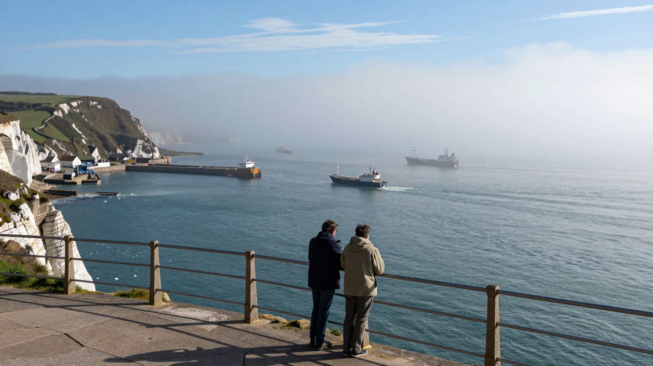
It doesn’t crash on the beach or roar over the cliffs. It creeps. One side of the Channel wakes to blue, the other sits in a flat grey bowl that never quite lifts. Ferries nose through it, pilots talk about it, and forecasters track a boundary that does not show on any map.
Some days, that line barely moves. Stand on the wrong side and the sun might as well not exist.
Where the murk stops and the sparkle starts
The English Channel is not one piece of weather, it is a meeting place. Colder water from the Atlantic slides in from the west, relatively warmer, shallower water sits closer to the French coast, and air masses from the continent and the ocean keep swapping places overhead. Fog is just cloud at ground level, and it forms where air is cooled to its dew point or loaded with enough moisture that tiny droplets hang on.
What makes the Channel strange is how sharply that can change over just a few miles. A bank of low cloud will sit solid from Dover to Dungeness, while Calais basks in sunshine. Or the opposite: Boulogne in a thick pea-souper while Folkestone is in shades and T‑shirts. To the people stuck in the grey, it feels unfair. To the atmosphere, it is geometry.
The “invisible line” is usually where cool, moist marine air meets drier, slightly warmer air flowing off the land.
When the air over the sea is only just colder than the water beneath it, a shallow layer of fog can spread and cling. Where that air crosses a sharper temperature jump or hits a breeze that mixes it upwards, the droplets evaporate and visibility bounces back. The result is a narrow zone where one side lives in a lighthouse postcard and the other looks like a July postcard.
A tug of war between land and sea
By late night and early morning, the set‑up is primed. The land on both sides has cooled quickly, heat has radiated back into space, and light winds allow moisture near the surface to build. Over the relatively slow‑to‑cool sea, the air rests on a mild, damp cushion. Radiation fog can form over the land and drift out, while sea fog can drift in. Where they meet, the boundary sharpens.
During the day, the land wakes up first. Sunlight warms fields, towns and cliffs much faster than the water. Warm air rises inland, creating gentle thermals and a shallow mixing layer that chews up low cloud. Over the Channel itself, especially in spring when the sea is coldest relative to the air, that mixing is weaker. Fog survives or reforms just above the waves.
That contrast sets up mini pressure differences and local breezes. A sea breeze nudging inland from the Channel will push the fog line a few kilometres onshore on the English or French side. A light offshore breeze does the opposite, sweeping dry air over the beach, punching a hole in the grey and leaving the fog sulking farther out.
Many days, the “deciding line” lies roughly along the point where the sea breeze from one coast meets the sea breeze from the other. The air there has nowhere to go but up, which helps to thin fog. A bit closer to one shore, the breeze may be too weak to mix the lowest layers, so the mist hangs on like stale breath.
The role of temperature inversions – lids on a low cloud pan
Above all this sits another quiet culprit: the temperature inversion. Normally, air cools with height. On calm, clear nights and in certain large‑scale pressure patterns, a layer of warmer, drier air can overlie a cooler, saturated layer near the surface. That cap suppresses vertical mixing. Fog and low stratus are trapped in a shallow pan.
Over the Channel, these inversions can be razor sharp. Weather balloons often show a two‑degree jump in temperature over just a few tens of metres above sea level. Below that, the air is near 100% humidity and calm. Above it, a gentle flow may be moving quite happily, carrying sunshine and high cloud that never make it down to the deck.
Where the inversion is strongest, fog is hardest to shake. A slightly stronger wind or subtle change in sea surface temperature can weaken that cap in one zone but not in another. You then get a strip where fog thins to low cloud or even ragged patches, and beyond it, a slab of stubborn grey.
The Channel’s fog line is often the edge of an invisible lid – a place where the cap is just about to break, but not quite.
Small details matter. A patch of slightly warmer water from a tidal front, a finger of colder outflow from the Seine or Thames, or even the wake of repeated ship traffic can tweak local temperatures by fractions of a degree. That is enough to tip air above or below its dew point and quietly shuffle the fog boundary.
Why one shore clears while the other sulks
From the beach, it can feel personal. You watch the forecast promise “fog clearing to sunny spells” and by mid‑afternoon, it still looks like a low ceiling. Across the water, webcams show blazing sunshine. The difference, nine times out of ten, comes down to three small shifts:
- Land heating and slope – South‑facing chalk cliffs and urban sprawl around, say, Brighton or Boulogne warm more quickly than flatter, marshy coasts. That extra heat deepens the mixing layer just enough to eat the fog locally.
- Wind direction and strength – A breeze of 6–8 knots blowing along the Channel can slide fog banks without tearing them up. Tip that breeze slightly onshore or increase it past about 10–12 knots, and the added turbulence shreds the droplets. One side may get that threshold, the other may not.
- Sea surface texture – Strong tides over sandbanks and headlands stir the upper ocean, slightly cooling or warming patches. Areas with upwelling or faster tidal streams often host more persistent sea fog, because the surface stays cooler relative to incoming air.
Put simply: if you are sitting above cooler water under a solid inversion with a light, laminar wind, the fog is likely to linger. If your neighbour across the Strait has a bit more chop, a kink in the coastline and a touch of extra sunlight on the slopes, they break free sooner.
The patterns pilots and skippers watch
For people who work in the Channel, the invisible line is not a curiosity; it is a shift in risk. A container ship leaving Southampton may cruise under clear skies until mid‑Channel, then run into a sudden wall of murk where visibility drops below 200 metres. A light aircraft routing from Shoreham to Le Touquet can cross from VMC (visual meteorological conditions) into IMC (instrument meteorological conditions) in less than a minute.
Forecasters and route planners lean on a few cues:
- Morning satellite images showing narrow tongues of low cloud hugging one shore.
- Observations of sea surface temperature gradients from buoys and satellites.
- High‑resolution models that simulate the lowest 100–200 metres of the atmosphere in 1–2 km squares.
They know that advection fog – moist air drifting over colder water – can fill the Channel in hours when a mild south‑westerly pushes moist Atlantic air over cold spring seas. They also know that radiation fog forming over French farmland on a still autumn night can spill over the coast and ride the first light northerly, stopping roughly where the sea surface no longer cools it enough to stay saturated.
The practical rule is conservative: assume the fog line is mobile and that good visibility can collapse faster than it improves. That is why shipping forecasts talk about “patchy fog” and “fog banks” even when many coastal observers see only a dull overcast.
How the invisible line shifts through the year
Season matters. In late winter and early spring, the sea is at its coldest while the air can turn relatively mild on sunny days. That is prime time for sea fog. Moist, mild air skimming over cold water cools from below until it hits the dew point, and broad fog layers can stretch from the Western Approaches to the Strait of Dover.
In summer, the roles reverse more often. The sea lags behind hot continental air, but stronger daytime heating on land tends to erode most coastal fog by late morning. The line between lingering sea mist and clear beaches moves offshore. You might see a white smudge on the horizon from Brighton or Dieppe while inland skies are bright blue.
Autumn is the deal‑maker season for inland‑to‑sea fog lines. Long nights promote radiation fog in low‑lying river valleys. When light offshore winds pick up, that fog can slide out over the water. It will persist over sections of the Channel where the sea is still just cool enough to keep the droplets from evaporating, and fade elsewhere. That creates strands and scallops in the fog edge rather than a single straight line.
Winter adds large‑scale pressure patterns to the mix. Under a broad high‑pressure system, inversions strengthen and the lowest layers of the atmosphere can become almost decoupled from what’s happening aloft. Low stratus and fog can lock in place for days on one flank of the Channel while Atlantic fronts skim harmlessly above.
When models struggle and humans still squint
Even with dense data and clever code, pinning the exact line is hard. Fog is a micro‑scale phenomenon riding on top of mesoscale and synoptic‑scale patterns. A model grid box might say “80% chance of low cloud, 40% chance of fog”, but whether that means Hartlepool clears at 11:00 and Hastings at 14:00 is beyond its comfort.
This is where humans still stand at windows. Coastal forecasters watch:
- How quickly visibility is changing at headland stations.
- The height of the murk against known landmarks.
- The feel of the wind shift as sea breezes start or die.
A report of “fog lifting to low cloud” at one port and “fog persistent” 20 miles down the coast can tell them where the lid is loosening. That information feeds updated shipping forecasts and aviation TAFs, even as the underlying model remains the same.
A simple picture for a complicated edge
If you strip the physics back, a workable mental model looks like this:
- Fog loves: cool surfaces, saturated air, weak mixing, strong inversions, gentle flows.
- Fog hates: sharp heating, stronger turbulence, drier air, broken inversions, stronger breezes with vertical gusts.
The Channel’s “invisible line” is usually the narrow strip where those loves and hates are balanced. A slight nudge in any direction – wind veering a few degrees, sun breaking briefly through thinner high cloud, a small swell change in sea surface temperature – tips the balance. One side clears, the other stays muted.
| Factor | Foggier side | Clearer side |
|---|---|---|
| Sea vs land heating | Cooler sea dominates | Warmer land mixes air |
| Wind behaviour | Light, smooth, aligned | Slightly stronger, gusty, mixing |
| Inversion strength | Strong lid, shallow moist layer | Weaker lid, deeper mixed layer |
From a clifftop in Kent or a dune in Pas‑de‑Calais, you can sometimes see the boundary as a faint white wall or a sharp horizon where blue turns to dull grey. Ships vanish into it and emerge minutes later into different weather.
FAQ:
- Why does the fog sometimes stay all day on my side but clear by mid‑morning across the Channel? Your side is likely sitting over cooler water under a stronger inversion, with weaker mixing. The other shore gets more land heating and slightly stronger breezes, which stir the lowest layers and evaporate the droplets.
- Is the fog line always in the same place? No. It shifts with wind direction, sea temperature patterns, tides and larger weather systems. On some days it hugs one coast; on others it snakes diagonally across the Channel or vanishes altogether.
- Can we predict exactly where the line will be? Forecasters can outline zones of higher fog risk and likely persistence, but the precise edge can depend on very small‑scale effects that models blur. Nowcasting with live observations often refines the position through the morning.
- Why does spring feel so foggy around the Channel? In spring, the sea is still cold while milder, moist air begins to flow in. That temperature contrast is ideal for advection sea fog, which favours the Channel and nearby coasts until the water warms later in the year.


Comments (0)
No comments yet. Be the first to comment!
Leave a Comment